

GIScience; Spatiotemporal Statistics; Bayesian statistics; Environmental health, spatial epidemiology and public health
Advanced models proposed by Dr. Chao Song
- I. Bayesian STVC model (2019, 2020)
- II. PST model (2018)
- III. B-GeoSVC model (2019)
- IV. DRRD model (2019)
- V. Improved Bayesian STVC-based models (upcoming)
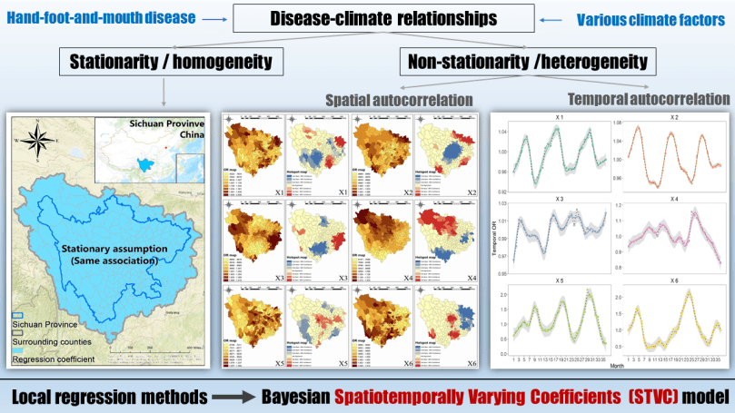
I. Bayesian Spatiotemporally Varying Coefficients (STVC) model for measuring local-scale spatial and temporal nonstationary relationships among variables (2019, 2020)
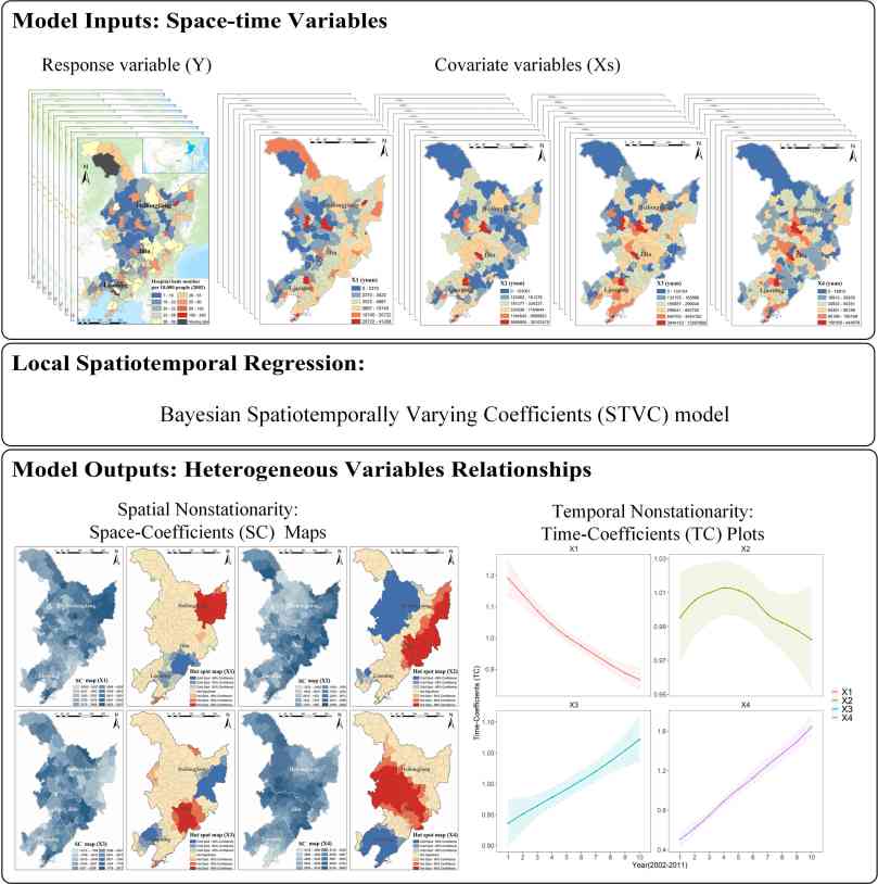
The Spatiotemporally Varying Coefficients (STVC) model is a first Bayesian-based local spatiotemporal regression to simultaneously detect spatial and temporal nonstationarity in heterogeneous response-covariate variables relationships, by taking advantages of both Bayesian statistics theories and hierarchical modeling framework, as well as through separately estimating posterior local-scale coefficients over different space areas and time points (Song and Shi, et al. 2019). In this case, the STVC model with logistic prior distribution was able to further spatialize the risk indicator odds ratio (OR) into local ORs to represent spatial and temporal varying disease-climate relationships. For hand, foot, and mouth disease (HFMD), by using local OR epidemiologic indicators, we detected local temporal nonlinear seasonal trends and spatial hot spots for both disease occurrence and disease-climate associations over 36 months in Sichuan, China. Download this article
(SCI, Q1, TOP journal, IF=5.589)
In a recent accepted article (doi: 10.1080/19475683.2020.1782469), we presented a literature review of the theoretical statistical basis on the newly proposed Bayesian Spatiotemporally Varying Coefficients (STVC) model, which is a first Bayesian-based local spatiotemporal regression method to detect spatial and temporal nonstationarity in heterogeneous relationships among variables. A general formula paradigm of Bayesian STVC modeling was introduced in detail for the first time, to provide a guideline for practitioners to develop the custom-built STVC models to solve broader issues in the real world (Song, et al. 2020).
Welcome to utilize this new Bayesian STVC model in your research, and feel free to contact us (chaosong.gis@gmail.com). Searching “Bayesian STVC” on Google or Google Scholar
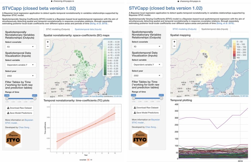
Online application: STVCapp (Since 2020) A BAYESIAN LOCAL REGRESSION APPLICATION TO DETECT SPATIO-TEMPORAL NONSTATIONARITY IN VARIABLES RELATIONSHIPS SUPPORTED BY BAYESIAN STVC MODEL.
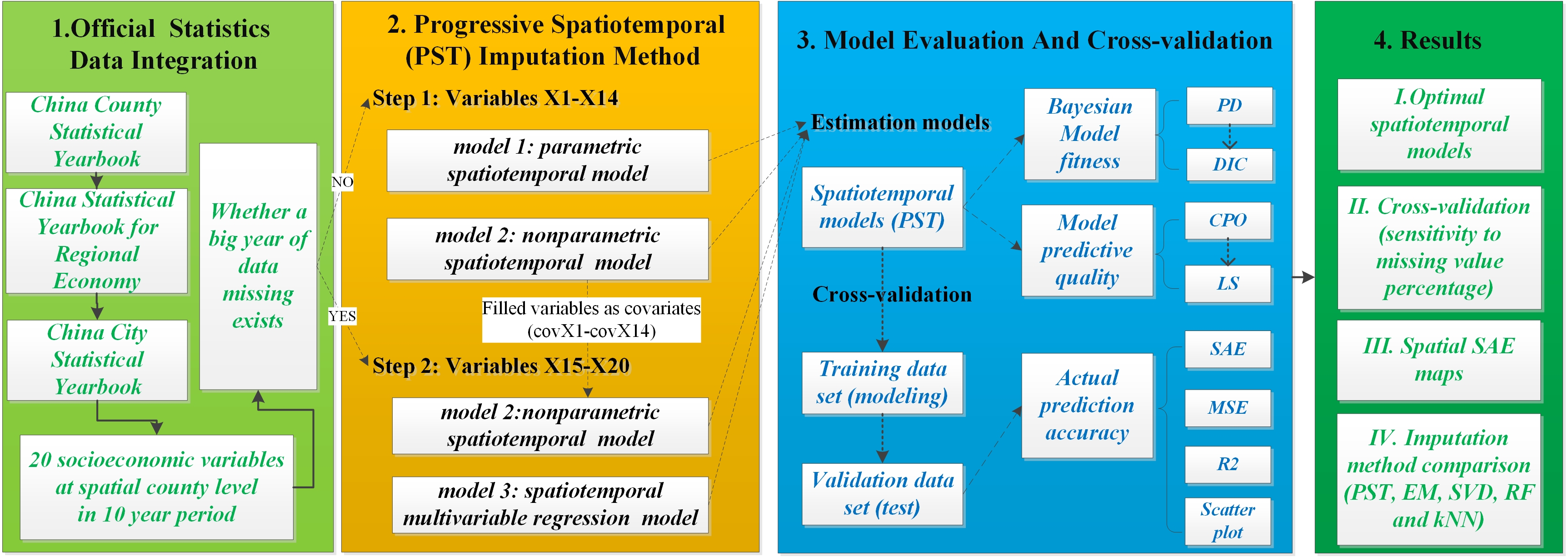
II. Progressive Spatiotemporal (PST) method for estimating missing data, even when neither samples nor auxiliary data are available (2018)
When neither samples nor auxiliary data, e.g., explanatory covariates information, are available for missing data estimation, which is a more difficult but common missing data situation, we developed a procedure to impute missing values under this condition within the Bayesian hierarchical modeling (BHM) framework. The procedure incorporates two novelties. First, it takes into account spatial autocorrelations and temporal trends for those easier-to-impute variables with small missing percentages. Second, it further uses the first-step complete variables as covariate information to improve the modeling of more-difficult-to-impute variables with large missing percentages. We applied this progressive spatiotemporal (PST) method to China’s official socioeconomic statistics during 2002-2011 and compared it with four other widely used imputation methods, including k-nearest neighbors (kNN), expectation maximum (EM), singular value decomposition (SVD) and random forest (RF). The results show that the PST method outperforms these methods, thus proving the effects of sophisticatedly incorporating the additional spatial and temporal information and progressively utilizing the covariate information (Song, et.al. 2018).
IV. B-GeoSVC regression model for fusing both regional and local-scale spatial heterogeneity (2019)
Our group developed a new integrated statistical method, named B-GeoSVC, under the hierarchical Bayesian framework for local-scale landslide susceptibility mapping (LSM) and risk factors assessment. Specifically, this model applied the GeoDetector method to fit the regional trends of control factors, and employed spatially varying coefficients (SVC) model to fit the local spatial heterogeneity of each control factor. Then, the regional trends and local spatial heterogeneity information were fused within the hierarchical Bayesian framework (Yang, …, Song. 2019).
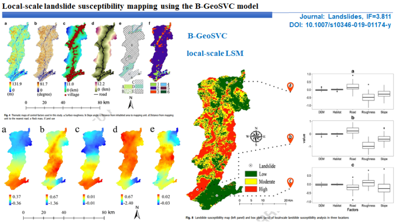
Yang Yang, Jintao Yang, Chengdong Xu, Chong Xu, Chao Song*:
Local-scale landslide susceptibility mapping using the B-GeoSVC model. Landslides (2019) published online: 13 April 2019. DOI: 10.1007/s10346-019-01174-y
(SCI, Q1, TOP journal, IF=4.252)
IV. Disease Relative Risk Downscaling (DRRD) model for assessing geospatial disease risks using newly proposed SOR, SRR and SAR epidemiologic indicators (2019)
Given the limitations of current approaches for disease relative risk mapping, it is necessary to develop a comprehensive mapping method not only to simultaneously downscale various epidemiologic indicators, but also to be suitable for different disease outcomes. We proposed a three-step progressive statistical method, named Disease Relative Risk Downscaling (DRRD) model, to localize different spatial epidemiologic relative risk indicators for disease mapping, and applied it to the real world hand, foot, mouth disease (HFMD) occurrence data over Mainland China.
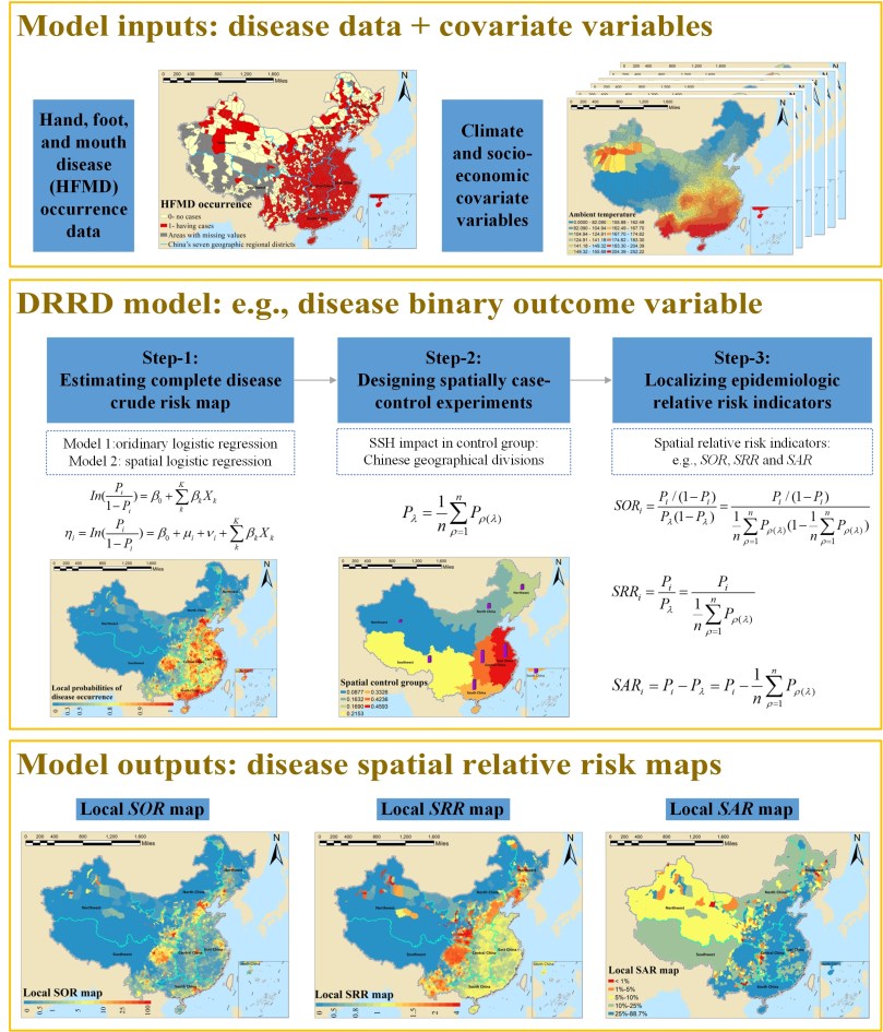
This manuscript (Chao Song as first author) is accepted in the journal “stochastic environmental research and risk assessment” (SCI, Q1, IF=2.807). DOI: 10.1007/s00477-019-01728-5
V. Improved Bayesian STVC-based models
Upcoming in 2021
Welcome to utilize our proposed models in your research, and feel free to contact us (chaosong.gis@gmail.com).
